                                                The Llanganates National Park is a protected area in Ecuador located between the Provinces of Cotopaxi, Tungurahua, Pastaza and Napo. Its name, "Llanganates", comes from the Quechua word that means "Beautiful Mountain", located inside the park is its highest elevation that is called with the same name, Cerro Hermoso. The park is famous for "El Tesoro de la Llanganatis". In the area that corresponds to Napo predominates the humid cloud forest. Due to its characteristics, the forest is used for biological research, especially for the abundance of orchids, bormelias and birds.

Or very irregular topography, with strong vertical slopes, where immense rocky outcrops, are characteristic elements of the high Llanganates its lagoons, forests of foothills and rivers that are born and advance towards the east to form Pastaza and Napo, tributaries Of the Amazon

The Llanganates or Llanganati meaning "beautiful hill", as they were known by the ancient inhabitants of the Sierra, were used as sacred sites by the indigenous people of Rumiñahui, the inhabitants of Píllaro, and after the Inca occupation they became a center Very important ceremonial or "huaca" (Uzcátegui 1992 cit. By Vásquez and Larrea 2000). The Incas used the Llanganates as a mining area, went in to extract gold from the mountains and created a road infrastructure whose traces can still be seen today (Anhalzer 1998 cit. By Vásquez and Larrea 2000).

The archaeological evidence found in the area suggests that the park was formerly inhabited by the same human groups that populated most of the mountain range in the time of the Kingdom of Quito. Tacaciga, Mulliambato and Píllaro cacicazgos exerted in their time influence on these groups, that were characterized by their active commerce at regional level.
The main road network that surrounds the area is the Pan-American Highway, which connects Latacunga with Ambato, Baños and Puyo.
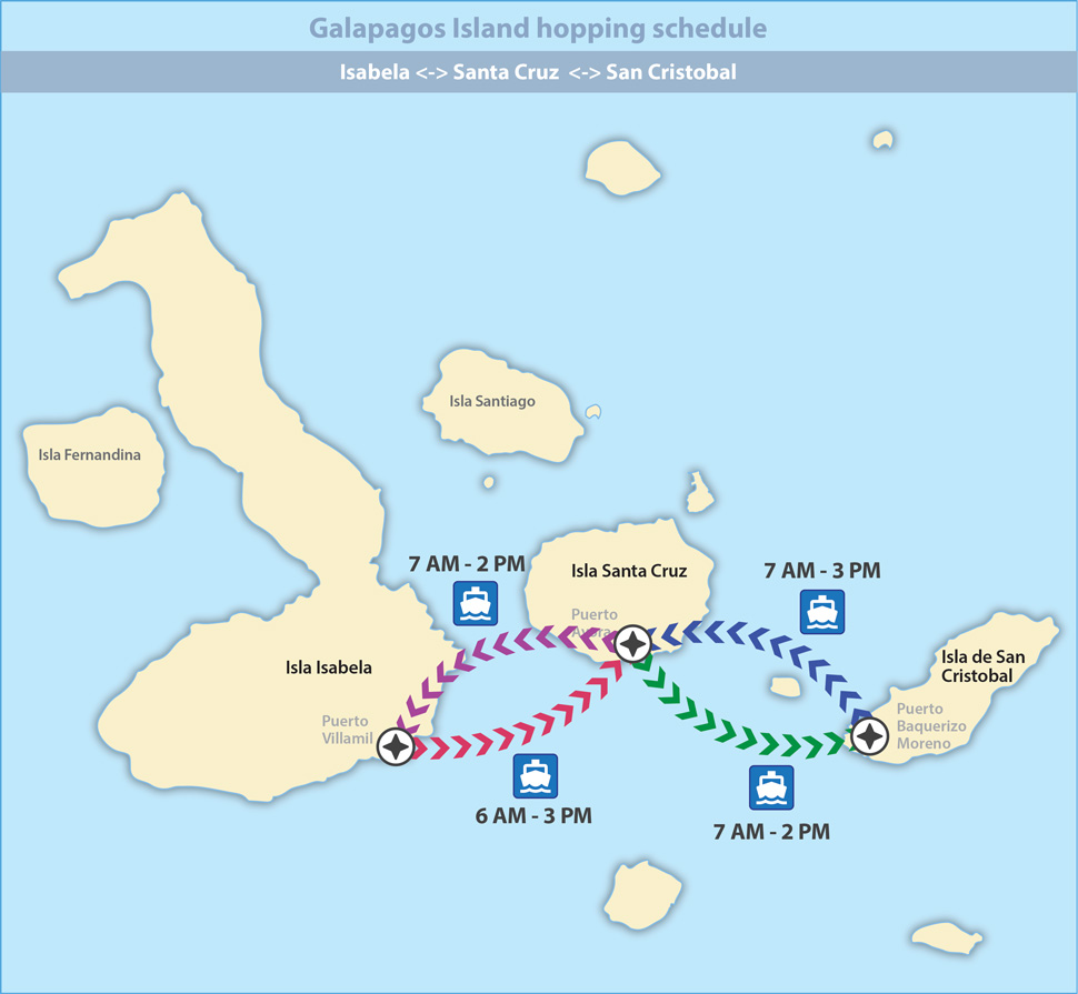
The Llanganates National Park is located 60 km north-east of the city of Ambato, by the way that leads to the canton Píllaro and the parish of San José de Poaló. The entrance is approximately 30 km, from the city of Salcedo.


 sitios turisticos de ecuador Tuesday 24 February 2026