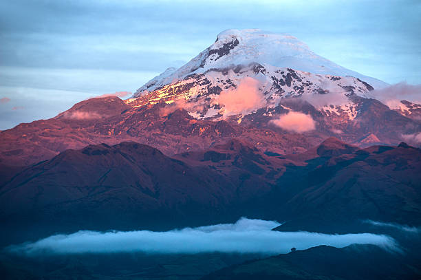
(6310 masl)
The volcano is ideal for mountaineering. There are many people who go to the foothills of the great mountain of Chimborazo. Foreign tourists come from all over to climb it and take advantage of the guidance and advice of specialized climbers.
According to the indigenous tradition, it is the "Taita" (Father) who together with the "mama" Tungurahua and the guagua Pichincha form a theological trilogy of volcanoes of the region. Its summit of 6268 masl is the highest in Ecuador and constitutes the furthest point from the center of the Earth.
The Chimborazo volcano next to the Carihuairazo volcano (5020msnm) is located in the Chimborazo Faunistic Production Reserve (58,560 ha) that encompasses the páramos surrounding the colossi. This reserve hosts a large number of Vicunas and their thaws feed the Pastaza River, a tributary of the Amazon.
The Chimborazo, according to diverse opinions, is an extinct volcano, whose activity goes back many centuries. This volcano, also known as "The Cyclops of the Andes". It is an ancient stratovolcano, between whose summits the crater is located, corresponding to its most recent activity. It is covered by huge glaciers that descend on all sides, occupying an area of 20 km2, whose ice volume is estimated at more than 2 km3.
• The Andinism: This sport is practiced, by preference, in the King of the Ecuadorian Andes thanks to its imponderable beauty. The Liberator, Simón Bolívar, was the first to practice it.
The most frequently used ascent routes are Normal and Whymper. It has two shelters: the Carrel cabin at 4,850 meters and the Whymper cabin at 5,000 meters. Due to the altitude and its extreme climate, we recommend your ascension hiring the services of a professional mountaineering and hiking guide.
ACCESS THE SUMMIT:
Reaching the summit of Chimborazo requires skill and dexterity so only people in good physical condition and well acclimatized achieve it. Many use the community of Pulinguí San Pablo (3990) on the Riobamaba-Guaranda route to acclimatise for several days before undertaking the climb.
The temperature can easily drop to -10 degrees Celsius. Make sure that the guide is certified by ASEGUIM (Association of mountain guides), you can find guides in the travel agencies of the city of Riobamaba or Quito. Most excursions take the "Normal Route" on the south-western side passing through the Carrel shelters at 4800m and Whymper at 5000m and it takes around 9 hours of climb and 3 of descent.
To get from Riobamba to the first Carrel refuge there is a distance of 50 km; Those who have private transport, should take the Panamericana Sur to the factory "Cemento Chimborazo" continue to San Juan and from there in 40 minutes you will reach the Carrel Refuge. By public transport you can travel by bus, buses from the Bolívar Fleet depart from the terminal twice daily (8:45 and 1:15 pm) that pass through the Carrel refuge.


 El Altar y su magia Monday 23 February 2026
 Tourism